22nd May

Two months on, we chose a lesser known place to walk, starting just east of Peter Tavy.  I had a possible 10 tors or rocks from Ken Ringwood's book to cover.  It did feel really good to be out in the fresh air again. From a small car park, it was an easy walk underfoot at first, climbing gradually, branching off towards Little White Tor first.  As we approached the summit, there was a fair bit of clitter, followed by big boulders near the summit.  Whether I was overconfident, or out of practice, or unbalanced with my walking poles, I'm not sure.  What I do know is that before we reached our first tor top, I sprained my ankle.  Not good at this stage of a walk or at the beginning of a summer where I hoped to be walking on the moor often.  Thankfully I could still walk on it (seems nothing broken), and we reached the summits of Little White Tor (430m) and then White Tor (468m).

We came down in hunt of Stephen's Grave [K4], where track and bridlepath cross.  Here lies (by legend of course) one spurned by a young lady who then took his own life.  There are a variety of versions of his demise and his burial is on the moor at the outskirt of the parish due to the death being by suicide.

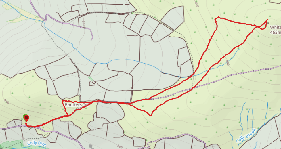
On the way back down, we were looking for Wedlake Tor, but the one we found was Setters Tor (363m).  Back along part of the track and a detour north took us to Boulters Tor (336m), and then Furze Tor (319m) close to the track. By this time, my ankle was beginning to hurt good and proper, and I was very glad to return to the car.

My big event is in the middle of June.  We had planned to camp for a week in North Dartmoor, and have a mega-tor walking spree.  Camping is now not possible, and I'm not sure yet whether I'll be able to walk far at all.  My dream of hitting Yes Tor on my birthday is not seeming realisable, but I guess that is why this is a year-long project!  It would be great if you were able to encourage me onwards and upwards by donating to one of my chosen charities for the year.  More details on the 'Get Involved' page.


20th March

An earlier start today, with pasties packed for lunch!  Starting from Shipley Bridge [U14], north towards the Reservoir, but scrambling up Black Tor (326m) first.  Then finding our way to Ryder's Rocks (393m), dodging the marshier bits of ground.

We then headed for two Barrows.  They're not tors, so don't count towards my Tor total, but were worth what was quite a tough walk underfoot.  Although the ground was not really soggy, the choice was between walking on tufts of grass with gullies in between, or paths which still thought they were boggy streams. As we approached Eastern White Barrow, Jonathan said it looked like a submarine, and sitting atop we laughed to find it is indeed nicknamed 'The Submarine'.

More tough ground brought us to Western White Barrow and Petre's Cross [S12], which apparently sits upside down!  The two barrows sit at approx. 472m and 477m so were our highest points for the day.

From here it was mostly down hill, over more rough ground.  Eventually we picked up a bit of the Two Moors Way, and found our way to the River Avon.  The Reservoir then came into view, and the path got gradually easier, and our pace quickened.  We did see a few others out walking - all being careful to keep our distance.  On the way back, we took note of Brentmoor House [T14], which you can see the shape of below.
Having missed it on the way up, we also found Hunters' Stone on the last bit of road, which bears the names of past Masters or the Dartmoor Foxhounds!  Over 8 miles walked.

The car park was much busier when we returned to Shipley Bridge, and we did wonder for how much longer we'd be able to enjoy our Dartmoor walks.  Dartmoor may be big, but it's hard to visit without starting at a car park or village, and we certainly can't get there on foot!  So we won't be back to continue my tor challenge for a while.  For now, I'm using an exercise bike to keep fit, and Jonathan is jogging.  The weeks will pass, but to scale 35 Tors in 80 days is not bad going, and we'll continue later in the year.

12th March

A longer hike this Friday fuelled by a good Sainsbury's breakfast.  It would be our last meal out together for a while.  We drove into Princetown in a hailstorm, which thankfully then blew over!  Startint from a small parking area north west of Princetown, we headed along the Yellowmeade Farm track.  The first 'Tor' was more notable for the lake, which is what is left to show for quarrying at this site - Foggintor (415m).


We then skirted around Swell Tor, and saw the Swell Tor Quarry Workings [N6].

From the Plymouth and Dartmoor Railway track, we branched off to climb Leeden Tor (389m) and along to Ingra Tor (339m).  Back along the track, passing under a bridge [Princetown Railway O6].  Although it obviously crosses the track, there is no discernable path either side - so it's hard to know quite why it is there!


Continuing around Swell Tor, we then left the track to climb Kings Tor (pictured, 400m), then returning to the farm track at Foggintor.  Nearly 6.5 miles walked, and as we drove back through Princetown, the hail returned!

6th March

We had a break from walking on Dartmoor, with a trip to Prague during the half term break.  Suffice to say, we walked between five and seven miles each day we were there!  The weather was wet when we returned, so it was March before we were out on the moor again.

We set off knowing rain was on the way, so well togged up!  From Two Bridges this time, towards Wistman's Wood, but heading east a little way up the track, to climb Crockern Tor (409m) [M10].  Then on along the ridge via  Littaford Tors (466m), and with rain blowing sideways into our faces, Little Longaford Tor (472m) and Longaford Tor (507m).  It did stop raining, but was still blowy, as you can see from this short clip!  We could see the Powder Mills from the top of Longaford [L10]


Thanks to the rain and wind, I was not up to carrying on to Higher White Tor, so we headed back into the valley, along the edge of Wistman's Wood [L9] and back along the track to Two Bridges. 4.3 miles total walked.

14th February

A St. Valentine day ramble just north of Burrator Reservoir. We started off in the dry, up Sharpitor (415m), then a scramble and climb up Leather Tor (390m). Just beyond, the weather changed to light rain. We found Lower Leather Tor (361m), and from there could see the reservoir. 
We were looking for Lowery Tor too, but couldn't work out quite where it was. Gradually the weather was closing in. With one more we hoped to reach, we headed North West towards Peek Hill. And then, on the way we spotted another outcrop, which we were able to identify as Lowery Tor (367m). Dodging the dampest bits od ground, we continued up Peek Hill, from where there was no peek at all - we were completely in mist. Very glad of gps signal as we headed back to the car!  

2nd February

An adventure on my own this afternoon, and more so than planned, as I succeeded in leaving my phone at home!  No photos or route map therefore. The mist seemed to envelope the car as soon as I crossed the moor cattle grid on the road out of Yelverton.

On reaching Princetown, I enjoyed a few sandwiches before heading off on foot.  Without the aid of GPS, it took two attempts to find the right path out of town, but once I left the houses behind me, it was easy to follow the wall upwards towards North Hessary mast.  I was very glad of the wall, as the mist rendered nothing much else visible!  I heard the mast before I saw it, then noticed wires heading up into nothingness.

Eventually the fence came into sight. Even from close by, the top of the mast could barely be seen. Suffice to say, I have no witnesses of my reaching the trig point on the rocks at the top (North Hessary Tor - 517m) and I didn't stay long due to the wind. I'd not seen a soul on the way up although there was a dog walker and some 10tors/DofE explorers as I made my way back.

I had hoped to visit three other tors, but mist and lack of phone put pay to that plan.  6th walk complete and 20 tors climbed. This is my highest peak reached to date - a climb of around 100 metres from Princetown.

24th January

Chose to travel to Tavistock via Callington today, having got stuck on the A386 at Roborough too many times last weekend. Much smoother journey. From there we headed onto the moor, stopping at the first car park. Tors for the day were Cox Tor (442m) [L4], Roos Tor (454m) and then Great, Middle and Little Staple Tors (455m, 431m and 382m).

Great Staple Tor [L5] is well known for its rocks, which make it a popular place with photographers. Not quite so photogenic in today's grey weather, so here's a shot courtesy of Liminal Light (my fellow walker) from another day.