31st August

 A Ten Tors challenge - based on this walk from alltrails.com, starting from Lydford High Down car park:

Across High Down Ford [F4], then these tors:

1. Arms Tor (457m)

2. Great Links Tor (591m)m [F5]

3. Higher Dunnagoat (562m) and Bleak House [F6]

4. Green Tor (543m)

5. Lower Dunna Goat (557m)  

6. Chat Tor (542m)

8. Hare Tor (531m)

7. Sharp Tor (519m) (My hundredth tor!)

9. Doe Tor (425m)

10. Brat Tor with Widgery Cross (452m) [G5]

Yes, numbers 8 and 7 are swapped because I made a mistake en route - the better way would have been Chat, Sharp, Hare then Doe, but we made it.  It's a good walk for views - this was a clear day and we could see the sea to the north and south at different times.  We did realise that it would have been good to include Little Links too, but maybe I'll go back later in the year.  Whether I will manage to reach all the tors over 500m remains to be seen.


23rd August

With the weather looking like it would be dry with good visibility on this Sunday afternoon, we drove to Okehampton Army Camp and onto the moor.  However, as we stopped for a sandwich, this is what greeted us!


We did consider turning around and going home again, but then it seemed to clear, so we drove on to the last parking space on the track near West Mill Tor and set off.  I wanted to start at the end of the ridge and make our way back along, so we headed up between High Willhays and Yes Tor, along to Fordsland Ledge (585m).  We spent some time identifying tors to the south, and then came back to Dartmoor's highest point, Hill Willhays (621m) [D7].

Along the ridge is Hampster Tor (618m) and then the well known Yes Tor (619m).  Near the track on the way down from Yes Tor is the Target Railway [C8], which we will return to visit at some point.  Instead we went up over Little Tor (531m) and West Mill Tor (541m).  It made a 4.5 mile walk with some good views - even if not as far as the sea this time!


15th August

Our last full holiday day - and it's wet.  But again, by the time it got to lunchtime I'd had enough of the tent, and we headed out.  Having decided not to do the big tors, I looked for a group of tors close together and on this side of the moor.  We parked near the Round Pound at Teigncombe, and first off, Jonathan disappeared with his camera to catch some shots of the pound and a tree he'd spotted there.  We ate our sandwiches and by this time it was properly raining.

Undeterred we donned wellies, waterproof coats and leggings, took a list of tors and set off.  Rain meant fog too, but thankfully we could see our first tor from the car.  At least we thought we could - aiming for Little Kes Tor, we actually arrived firstly at Kestor Rock (437m) [F13], so had to change plans a little.  

The next tor was then in sight - Middle Tor (415m).  Thankfully there is an overhang which can be crouched under there, so I was able to see that Little Kes was north of Kestor Rock, and we might be able to find it later.  On Middle Tor we found the rock basin - I've been looking for one of these before - this one was filled with water!

From Middle Tor, we headed onto Frenchbeer Rock (387m) - again just visible through the fog.  We then made our way to Thornworthy Tor (424m), came back over Kestor Rock and on to Little Kes Tor (393m).  Three miles walked, five tors covered, and pretty bedraggled!  On a bright day, if you're happy to do Devon back roads as they're pretty skinny to get to Round Pound, this would be a good family walk.  There are views of Fernworthy Reservoir from Thornworthy Tor, and loads of stone circles and rows to investigate.


14th August

A longer walk was due today, and it looked like it might at least not rain all day.  We drove on to the more from Okehampton Camp again, this time stopping at the car park near Row Tor.  It was foggy - no tors to be seen, but the paths were mostly going to be tracks and therefore easy to follow, so off we set.

We took the track which follows Black-a-ven Brook, crossing New Bridge and passing the base of Curtery Clitters (512m),  before taking a path up to East Mill Tor (513m).  I was grateful to my maps.me app for this one - it sometimes includes paths which aren't on the OS maps.  And GPS, of course, as the fog meant we couldn't see the tor itself until we were nearly there.  

There are several outcrops - we arrived at one, and saw another as we continued southwards, but the others were out of sight.  We made it back down to the track a little further along, ready to head on to our next tor.

At the next track crossroads, we turned right, and after a little while began to climb.  The path here rises 60 metres in about 600 metres - I counted the water channels (10 I think) to get me up to the top! Left at the top of the ridge, still on a good track, leads to Dinger Tor (542m) [E8].  Gradually the fog was getting thinner, and from here we could see Hangingstone Hill, Steeperton, Wild, High Willhays and Yes Tors.  Dinger itself is well worth a visit - a classic tor and easy to reach on the moor tracks.

We headed back, staying on this 'high' road, which runs along the west side of High Willhays and Yes Tors.  The one decision I did make here was that I wanted to do those high points when they weren't in fog - so that probably meant not during this holiday.  West Mill Tor was close to the path as we descended, but the more obvious one to go over on the way back was Rowtor (468m).  There we did feel a few spots of rain, but thankfully it held off.  In fact we had a couple of hours in Okehampton afterwards too with no rain too.

13th August

We had the delights of a cream tea booked today, courtesy of a gift from a friend.  At last it was a little cooler, although storms were on the forecast.  First off we drove in search of the most easterly tor from Ken Ringwood's book.  We left the A382 at Slade Cross, and shortly wished we'd taken a different route to Hennock!  We had to reverse some distance at least four times to get beyond one particular corner on the road.  I say 'we' - Jonathan was driving, and a good thing too, as I would have really struggled to do that!  Eventually we got through, and after rather more back roads, drove through the village to Five Lanes, where we managed to find a place on the road to park, knowing it wouldn't be for long.  

Bottor Rock (250m) is just about visible from a bridlepath which winds its way between some rather large houses north west from Five Lanes.  It's about a third of a mile from the junction.  I was glad I'd read this description earlier in the day - it helped us look for a path up the bank to the rock.  We didn't take too many steps towards the rock, but it was visible behind the trees.  Possibly there would be better views of it in winter.

Taking an easier route out of Hennock, we stopped briefly in Bovey Tracey, then in Moretonhampstead [F18] where we visited the tourist information centre and stopped on a hot bench with our sandwiches.  We then visited Moretonhampstead Motor Museum.  I'd really recommend it - it's a private collection of cars and motorcycles from the early 20th century onwards.  If you have any interest in cars, motorbikes or generally engineering and mechanical history, it's well worth dropping in.  I'm not a petrolhead, but there are some good stories behind the cars, and the painstaking restorations are really impressive.

We then took a scenic route towards Two Bridges - stopping at the viewpoint above Lettaford, and then driving through Challacombe [K14] and back to the road passing Soussons Down.  Sky was beginning to darken, and there were rumbles of thunder.  We made it into the hotel carrying our raincoats - and then got drenched walking back to the car after our cream tea!  If you visit Two Bridges Hotel for a cream tea - the scones are huge - one was plenty, but as we were brought four altogether we did make a good effort and manage three between us.  Decorated the Cornish way, of course!  On the way back we pulled into the car park at Postbridge, simply because the rain was too heavy for safe driving.

12th August

Suffice to say, after yesterday's yomp, I was not up to much today.  Plus it was still really hot.  We had a quiet morning, but by lunchtime I wanted to get off the campsite.  Castle Drogo [D17] is not far away and although the gardens were fully booked, we could see it was possible to park, and wondered about walking into the Teign Valley from there.  

We started walking around 2pm and it was very hot.  There were a couple of tors here - firstly Sharp Tor (220m) - one of the many.  It's clearly marked from the beginning of the walks from the National Trust Car Park.  The Tor is within the valley, with good views downwards and on out of the valley.  A path then is cut along the hillside (Hunter's Path), but the bits without shade were also without breeze, so quite stifling.  The other tor here is Hunter's Tor (193m).  Again, you can look down into the valley and out from here.  It's worth visiting both tors - the best view of each is probably from the other tor! 


We considered taking a path straight down from the tor into the valley, but I was just too hot and bothered.  So it was back along the hot path, pausing for water and air at each little bit of shade along the way.  Very glad of a cold drink and iced lolly from the cafe when we got back to the car park.  

11th August

The day for a long walk. Lots of water required, plus suncream and hats. We parked at East Okement, the end of the road for vehicles other than rangers and the military.  The aim was Hangingstone Hill, and maybe others on the way.  The track is easy walking for a mile or two, then the first decision was whether to go over Steeperton.  It held some mystique for Jonathan due to Ten Tors memories, and we were able to plan an approach from the easier north east, so off the track we headed.   It was down first into Steeperton Gorge, and a snack stop. Then south before taking the north easterly path up to the top. There are several outcrops on Steeperton Tor (532m) [D10], and an army hut which provided some welcome shade.  On such a sunny day we were able to identify many other tors, and make plans for our next summit. 

There was a fairly straightforward path down to the ford over Steeperton Brook [Knack Mine Ford E9], then we could see the path up to Wild Tor (531m) [E10]. The rocks here are really impressive and again we were glad they provided some shade.  Suncream was reapplied!

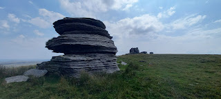
Somehow Jonathan persuaded me it was worth also heading to Watern.  I'm not sure how, as it was so hot by this point. We started on a path down into the valley, but it wasn't at all clear. I did find pushing our way through grass quite hard going. Were I to do this again or advise others, I'd say get to the line of firing range boundary posts as soon as you can - there's a path which follows them down to the water. Going down took us out of the little breeze that there had been on top, so we didn't stop for long near the water.  We then wiggled our way up Watern Tor (537m), also with Thirlstone (526m) [F10], pictured in black and white below. A shady rock and lunch required although we'd had lots of snack stops already!  


We could see the path to Hangingstone, albeit a bit of down and up again! Once we reached the ridge, the walking got easier, and as we were already over five miles, I was very glad of this. Our highest point of the year so far at 596m, Hangingstone Hill is mostly good for the views rather than the tor itself!  


We were then on good paths to descend into Steeperton Gorge. There was a long way to go, but a few clouds now, so not quite so exhaustingly hot. As we crossed the water, some other walkers stopped to talk - they were out for the day from Saltash!  

Rather than retrace our steps, we continued north out of the gorge, heading for Oke Tor (466m) [D9], before making our way back to the car. 


We'd walked 10.3 miles and climbed over 1500 feet in just over six hours. A great sense of achievement, though, to add six Tors to my list, five of which were over 500m high.


10th August

The beauty of coming from Cornwall to Devon for a holiday is a relaxed morning packing the car, a short drive and tent up by 3pm.  I was itching to walk too, so we headed straight out for the nearest tor over 500m.  We parked just off the road near South Zeal, and found the bridlepath we were looking for quite easily.

It was then a pretty continuous up, as we climbed nearly 1200 feet in two miles!  Cosdon Beacon (550m) stands alone here, with its cairns and granite outcrop.  I'd like to say we followed the planned paths, but the sight of a standing stone off to the east did take us on a bit of a rabbit's trail on the way up.  Then on the way down, the bridle path was nowhere to be seen!  So there was lots of crossing grass tummocks and following sheep trails.  Even back on the main path lower down, I took an off-piste route along a lovely wooded path which left us with a longer walk back to the car...

No storms yet, they're promised for later this week!


5th August

Four of us walked together today, as my eldest daughter and husband are currently staying with us.  Dartmoor was, well, Dartmoor, and they were glad we'd togged them up with raincoats and wellies!  As we passed through Princetown, North Hessary mast was nowhere to be seen, but the visibility on reaching Postbridge was not quite so bad.  The plan was to reach a few Tors over 500m just west of Littaford and Longaford Tors.

We took the bridle path north west from the Postbridge car park, gradually upwards, following paths where we could, although it wasn't always clear which was right, so there was a lot of GPS checking! We eventually spotted Broad Down Tor, which is not where Broad Down is marked on the OS map.  The tor we were heading for first was Braddon Tor (514m).  This tor, also known as Row Tor [or Rowter Moor J10], is several outcrops, some more obvious than others - here is Jonathan on top of what was probably the highest.
Between Braddon and  Lower White Tor (507m) it did rain a little - so it wasn't just the wind we needed waterproofs for!  It was a dip down and then up again, and a little easier to spot ahead of us.  From Lower White, a bit more of a climb to Higher White Tor (517m) [K10].  In the photo you can see the top cairn over Emily's shoulder.


It was then an easterly walk back down into Postbridge.  Three more tors over 500m complete in just over 5 miles.  Jonathan and I spent some time later in the day planning some more walks for the second week of our holidays, too.